
Much of our technical work directly or indirectly supports the acquisition and transfer of water rights for our clients. For the projects listed below, we provided technical support, including hydraulic analyses, to address water availability, impairment to existing users, and/or the “value” and validity of historic water rights.
Projects
Client: City of Lacey
Location: Thurston County, Washington
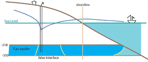
The City of Lacey plans to develop two new water sources in the Hawks Prairie area, which occupies a peninsula in Puget Sound. Given the proximity of these sources to the marine shoreline, the potential for seawater intrusion into the deep confined aquifer required investigation. To support the City’s water right permit, NLW prepared a technical document that not only described hydrogeologic conditions but also outlined detailed a monitoring strategy to ensure that groundwater development would not induce seawater intrusion. The document was based on previous characterization work by NLW, the City, and other consultants and researchers.
One notable aspect of this project was our involvement with the stakeholders. We worked cooperatively with them to negotiate the content of the technical document. As a result, each party was satisfied that water was available for beneficial use and that the proposed monitoring would be sufficient to prevent seawater intrusion. The process was efficient and the document has been effective.
Client: City of Auburn
Location: Pierce County, Washington
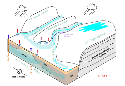
For nearly a decade, this client was engaged in planning and technical analyses related to the Cascade Water Alliance (CWA) project, which would transfer water from Lake Tapps to communities east of Lake Washington and on the Sammamish Plateau. NLW prepared multiple reports to document the project’s potential impairments to the City’s water rights and resources. In particular, we documented the hydraulic connection (via groundwater) between the White and Green River watersheds and its implication for water rights in these two watersheds. We also investigated the impairment of City water rights under the CWA’s operational scenarios for Lake Tapps.
NLW’s related work for City has included developing water supply scenarios and associated mitigation options. These options included using the new CWA Lake Tapps source as a water supply. The City ultimately decided to negotiate with CWA to purchase a portion of the Lake Tapps supply.
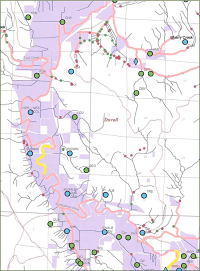
Client: Washington Water Trust
Location: Various counties in Washington
The Washington Water Trust helps transact water-right purchases for the environmental benefit of streams. NLW worked with this client to develop GIS-based products — specifically, a set of watershed maps and a set of county maps — for use in assessing water rights. The county maps included many themes associated with both land and water resources that could be used to assess the “value” of existing historic water rights for purchase and transfer transactions:
 Surface water rights
 - ESA-listed fish stream reaches
- Agricultural parcels
- Water-quality impaired streams
- Stream gages
- Public lands
- Construction permits
- Sub-watersheds
- Conservation lands
- High-ecological-value land
NLW associated water rights with active agricultural lands using several techniques, including name matching and location criteria. Multiple data tables were also constructed so the Trust could identify landowners with water rights. Deliverables included:
- A total of 29 WRIA maps showing water rights, ESA-listed fish, and water-quality impaired streams
- A total of 12 maps showing water rights and various natural resource features for sub-watersheds
- Data tables linking landowners and water rights