
NLW specializes in characterizing the hydrogeology of watersheds, a process that often entails assessing the complex relationship between surface water and groundwater. Depending on their scale and the client’s goals, these projects may require field, hydrogeochemical, modeling, and GIS, and/or other analyses.
Projects
Client: Spokane County Conservation District
Location: Spokane & Whitman Counties, Washington
 Faced with continued development in the areas surrounding the Spokane Valley, Ecology has been funding studies and monitoring efforts to better understand water availability. This project was an extension of a hydrogeologic characterization we conducted for middle- and upper-Hangman Creek. It entailed conducting a hydrogeologic and geochemical characterization and drilling monitoring wells in the West Plains and lower Hangman watershed.
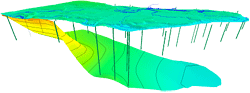
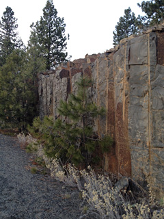
The wells were drilled in basalt aquifers and glaciofluvial sediments. Three of the five wells/boreholes were completed in the West Plains. We used information obtained during drilling, along with Spokane County’s GDB, to characterize the paleochannel, basalt, and crystalline basement rock along four cross sections through the West Plains. The cross sections show the hummocky basement rock and variable thickness and extent of the basalt. They also reveal the challenge of tracing continuous aquifers over long distances.
NLW collaborated with Spokane County to sample and analyze groundwater chemistry, including stable isotopes, major ions, and age dates. Our analysis revealed that groundwater from the basalt aquifer is thousands of years old, suggesting the need for careful and planned groundwater development. Geochemical data also indicated that deep water was mixed with shallow water — a result that reinforces the use of best management practices on developed land. This project added valuable water resource data to body of information that will form the West Plains conceptual model.
Client: Keta Waters
Location: Mason County, WA
Since we began working with the WRIA 14 planning unit and technical advisory committee in 2004, NLW has continued to expand and refine the hydrogeologic knowledge base in the Kennedy-Goldsborough and Johns Creek sub-basins. Mostly recently, we completed a multi-year framework project to define hydrogeologic units in a 90-square-mile study area. This work began as joint project between the Squaxin Island Tribe and the City of Shelton and later became a collaborative effort with USGS, which was working in an overlapping and adjacent area. Ecology is currently using the framework developed by NLW and the USGS in a numerical groundwater flow model. This model will support water management decisions about senior rights, source substitution, and mitigation in the Johns Creek sub-basin.
Our work for the hydrogeologic framework included developing 33 digitized, working cross sections with well logs (from 385 well records). Because the primary project goal was converting the upper surfaces of hydrogeologic units to MODFLOW layers, we define fixed points or polylines along the cross sections that the digital surfaces needed to honor. A final section was produced for the project report, along with extent and thickness maps.
Other significant work products included maps depicting the difference between NLW and USGS surfaces in the overlapping study areas. These maps allows reviewers to understand differing interpretations made by various hydrogeologists. All digital data was catalogued and transmitted to our client, Keta Waters, in a format for direct use in a groundwater model pre-processor.
Client: Spokane County Conservation District
Location: Spokane & Whitman Counties, Washington
 NLW developed a hydrogeologic conceptual model in the 675-square-mile Hangman Creek watershed to help planners make water resource decisions. This work entailed creating a 3D hydrostratigraphic database comprising 182 wells and generating 5 cross sections to show the relationship between Columbia River Basalt Group aquifers and local creeks. Six monitoring wells ranging in depth from 100 to 500 feet were drilled and tested to better understand the hydrostratigraphy, aquifer and well yields, and water geochemistry (including stable isotopes, carbon-14, and tritium). We also conducted a build-out analysis to estimate the potential water use from future land development. Finally, we developed recommendations for managing land and supplying water outside of service areas. The results and recommendations were presented in several venues that included local stakeholder meetings and a NGWA conference.
Client: Yinger Assoicates
Location: Deschutes County, Oregon
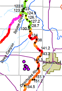 The developers of the proposed Thornburgh destination resorts near Bend, Oregon, planned to withdraw groundwater from aquifers that discharge into the Deschutes River and its tributaries. Citizens were concerned about the cumulative impact on groundwater resources and riparian fish habitat. To address these concerns, NLW modeled the effects of these withdrawals on the local flow system using a model that the USGS constructed for the upper Deschutes basin. We adapted the model to run with the pre- and post-processor Groundwater Vistas and compared the USGS results to our simulations, which included the proposed water supply wells.
The model showed that almost all the proposed pumping eventually manifests as reduced streamflow. It also helped us identify which reaches would be most impacted — information that is critical to developing a successful mitigation plan and evaluating impacts to stream temperature and fish habitat. In addition, we used the model results to identify water level declines and evaluate the impacts on neighboring wells. We also compared hydrologic and water rights data used in the model to data collected subsequently. This allowed us to make qualitative judgments about the model results and future water resource impacts.
 Client: WRIA 14 Planning Unit
Location: Mason County, Washington
NLW recently completed a hydrogeologic investigation for WRIA 14 in western Washington. The investigation entailed several tasks that not only improved our understanding of the area’s hydrogeology but also yielded data for future studies. These tasks included:
- Developing, and later refining, the preliminary conceptual model
- Monitoring water levels to assess aquifer responses to natural and induced stresses
- Collecting water samples and analyzing them for chemical parameters and environmental isotopes
The isotope samples provided information about groundwater age and flow patterns in the focus area. WDOE well records were incorporated into a project database and supplemented with published data. In addition, many wells were surveyed in the field to obtain accurate location and elevation information. We analyzed drillers’ well logs to identify key hydrogeologic contacts and then incorporated this data, along with water level information, into a project database, linking to Viewlog to develop a 3D conceptual model.
Client: WRIA 14 Planning Unit / Squaxin Island Tribe
Location: Mason County, Washington
The Johns Creek sub-basin features a substantial area of undeveloped land and fish habitat. The WRIA 14 Planning Unit faced a unique opportunity to proactively manage growth so that people and fish could coexist sustainably in the future.
Land development and population growth pose two significant challenges in areas where the surface and groundwater systems are connected. First, traditional development practices can alter the natural hydrologic processes of runoff, recharge, and storage, impacting not only the availability of drinking water but also the amount and timing of water delivered to creeks that support fish habitat. Second, withdrawing water for domestic, irrigation, or industrial uses reduces local streamflows.
Our work for this project entailed identifying possible impacts to flows at the sub-basin scale, projecting future water demand conditions, and exploring potential impacts to habitat under one of many possible future development scenarios.
Client: Plateau Technical Communication Services / WRIA 14 Planning Unit
Location: Mason County, Washington
NLW worked with PTCS to develop the WRIA 14 Watershed Management Plan. In addition to providing technical support and review, NLW researched options for addressing key issues related to water quantity, water quality, and instream flows. The plan was intended to guide water management decisions in this largely rural basin. As such, it involved input from various stakeholders, including several municipalities, the Squaxin Island Tribe, environmental groups, developers, and other interests.
Client: Anchor Environmental / WRIA 9 Technical Committee
Location: King County, Washington
NLW completed portions of a strategic assessment for the Middle Green River. Our work, which focused primarily on the groundwater system and its interactions with surface water, entailed compiling data from numerous sources and performing qualitative and GIS-based analyses. Specific tasks included:
- Identifying reaches with significant groundwater discharge to the Green River
- Mapping precipitation recharge using GIS
- Assessing the hydraulic connection between large wells and local streams and/or the Green River